South Fork Gualala
Overview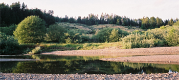
The 64 square mile South Fork Super Planning Watershed (SPW) drains 21% of the watershed through 140 miles of streams.
The Ft. Ross-Cazadero Road spans the ridgeline which defines the southern boundary and the headwaters of the South Fork. From that point the South Fork flows northwest, encounters the San Andreas Fault Zone, and continues along the rift zone until it it meets the North Fork Gualala and makes a left turn towards the Pacific Ocean.
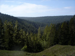
During the mid to late 1950s throughout Wild Cattle and Palmer canyons (upper South Fork) the coniferous forests were removed during an area-wide conversion with the intent to maintain a permanent conversion for grazing use.
Two large fires have burned through the headwaters of the South Fork causing the further removal of the coniferous forest. The Charles Fire in 1954 burned 10,000 acres, and following the same path as the Charles Fire, in 1978 the Creighton Ridge Fire burned 12,000 acres.
Current Condition
 Salmonids use the lower South Fork and the Gualala main-stem as a corridor to and from watershed tributaries.
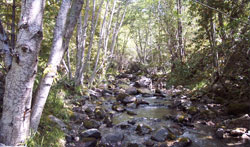
In the winter you will find adult salmonids holding in deep pools waiting for the water levels to rise so they can swim up the tributaries to spawn. Juvenile salmonids use this same stretch of the river, swimming down from the headwaters to smolt and head out into the Pacific Ocean.
Stream temperatures in the basin are suitable to moderately suitable for steelhead but are high for Coho rearing in most areas, a few exceptions exist in the lower South Fork; Groshong Gulch, Big and Little Pepperwood and in the Upper South Fork; Wild Hog, Carson and Camper Creeks.
Monitoring Findings
 Between 1998 and 2011, twenty-five (25) surveys were completed at five (5) reaches in the South Fork watershed. The reaches are located on the South Fork Gualala (217, 402), Big Pepperwood Creek (218), Carson Creek (631), and McKenzie Creek (615). Sites 217 on the South Fork and 218 on Big Pepperwood Creek are reference reaches and are monitored regularly.
Three reaches within the lower sub-watershed have subsequent surveys from base year monitoring and can be evaluated for changes in thalweg elevation and pool formation. The South Fork reach (217) is above the confluence with North Fork and the South Fork reach (402) is above the confluence with the Wheatfield Fork. Thalweg elevation and pool formation appears to be stable.
Big Pepperwood reach (218), monitored annually since 2002, is part of the Wood In the Stream Program and 37 logs and root wads (6151 cubic feet) have been placed in the reach. Thalweg elevation response has been a decrease of 1.39 ft. since 1998 and pool formation and depth has continued to increase since wood placement.
Carson Creek (631) and McKenzie Creek (615) are in the headwaters of the South Fork. Base Year surveys show good channel diversity and canopy density but a lack of abundance of deep pools and large wood.
Restoration
In the lower South Fork the National Marine Fisheries Service (NOAA) designated the Big Pepperwood planning watershed as a Core area for restoration and in the headwaters; Upper Marshall Creek, Lower Marshall Creek and the Upper South Fork are designated as Phase I planning watershed for restoration.
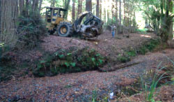 Road restoration is complete in the Pepperwood and Groshong watersheds and both are part of the Wood In the Stream program where 95 logs and rootwads have been placed to increase salmonid habitat.
In the Upper Marshall and Upper South Fork planning watersheds 22 miles of road have been upgraded by the Gualala Ranch and Sea View communities.
Restoration in the upper South Fork has included both upslope forest management and in-stream restoration on the South Fork by Ft. Ross Restoration, a grass-roots organization from the Gualala Ranch.
Land use
 Overall the landscape of the South Fork SPW is 73% forest, but it varies from a dense redwood forest along the main-stem of the South Fork to an open hardwood and grassland composition in the south. Along the 64 miles of the South Fork Gualala riparian conditions change from a 90% redwood forest in the north to a 30% mixed conifer stand in the south.
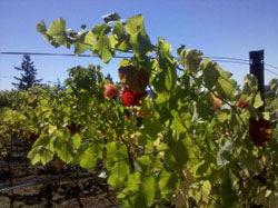
Vineyards in the watershed are primarily confined to Upper Marshall, Lower Marshall and the Upper South Fork planning watersheds. Five hundred and nine (509) acres or 1.25% of the South Fork SPW are in vineyard production with the highest concentration in the Lower Marshall Creek PW.
Gualala Redwoods and Bed Rock, Inc. are permitted to remove aggregate from river bars in the lower South Fork between Valley Crossing and the confluence of Big Pepperwood Creek. Mitigations include the funding of large wood placement in the Pepperwood Creeks (Big and Little) and Groshong Gulch along with the excavation of side-channel alcoves that provide cool water refugia for young salmonids.
| Planning Watershed | Acres | Stream Miles | Road Miles | Roads per Sq. Mile | Current Temperature Sites | Monitoring Reaches Proposed | Monitoring Reaches Installed |
|---|---|---|---|---|---|---|---|
| Big Pepperwood Creek |
6531 | 22 | 84* | 8.3 | 10 | 3 | 2 |
| Mouth of Gualala River |
5305 | 13 | 67 | 8.2 | 4 | 2 | 1 |
| Middle South Fork |
7910 | 24 | 44 | 3.6 | 0 | 1 | 0 |
| Upper South Fork |
8403 | 27 | 57 | 4.4 | 1 | 5 | 0 |
| Lower Marshall Creek |
6016 | 22 | 35 | 3.8 | 0 | 2 | 0 |
| Upper Marshall Creek |
6619 | 26 | 41 | 4.0 | 7 | 4 | 2 |
| SF Total | 40784 | 134 | 328** | 5.2 | 22 | 17 | 5 |
*High and medium priority roads are upgraded. Funding provided by the landowner, Gualala Redwoods, Inc. and the California Department of Fish and Game FRGP Program.
**Overall 27% of the watershed's roads have been upgraded.
Geologic and Geomorphic Features Related to Landsliding Map
California Geologic Service
2003
(5.9 MB)